


245801 - 801 Voting District, Richmond County, Georgia
About
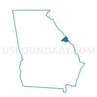
Outline

Summary
| Unique Area Identifier | 562794 |
| Name | 245801 - 801 Voting District |
| County | Richmond County |
| State | Georgia |
| Area (square miles) | 12.32 |
| Land Area (square miles) | 12.29 |
| Water Area (square miles) | 0.03 |
| % of Land Area | 99.79 |
| % of Water Area | 0.21 |
| Latitude of the Internal Point | 33.29474220 |
| Longtitude of the Internal Point | -82.22012310 |
Maps


Graphs
Select a template below for downloading or customizing gragh for 245801 - 801 Voting District, Richmond County, Georgia


Neighbors
Neighoring Voting District (by Name) Neighboring Voting District on the Map
- 0330002 - FOUR POINTS Voting District, Burke County, GA
- 0330006 - KEYSVILLE Voting District, Burke County, GA
- 1630081 - WRENS Voting District, Jefferson County, GA
- 245801B - 801B Voting District, Richmond County, GA
- 245803 - 803 Voting District, Richmond County, GA
- 245804 - 804 Voting District, Richmond County, GA
Top 10 Neighboring County Subdivision (by Population) Neighboring County Subdivision on the Map
- Hephzibah CCD, Richmond County, GA (20,618)
- Fort Gordon CCD, Richmond County, GA (8,992)
- Wrens CCD, Jefferson County, GA (5,179)
- Keysville CCD, Burke County, GA (2,833)
Top 10 Neighboring Place (by Population) Neighboring Place on the Map
Top 10 Neighboring Unified School District (by Population) Neighboring Unified School District on the Map
- Richmond County School District, GA (200,549)
- Burke County School District, GA (23,316)
- Jefferson County School District, GA (16,930)
Top 10 Neighboring State Legislative District Lower Chamber (by Population) Neighboring State Legislative District Lower Chamber on the Map
- State House District 123, GA (49,250)
- State House District 122, GA (45,723)
- State House District 142, GA (45,637)
Top 10 Neighboring State Legislative District Upper Chamber (by Population) Neighboring State Legislative District Upper Chamber on the Map
Top 10 Neighboring 111th Congressional District (by Population) Neighboring 111th Congressional District on the Map
Top 10 Neighboring Census Tract (by Population) Neighboring Census Tract on the Map
- Census Tract 108, Richmond County, GA (8,992)
- Census Tract 9601, Jefferson County, GA (5,179)
- Census Tract 109.03, Richmond County, GA (5,141)
- Census Tract 109.04, Richmond County, GA (3,726)
- Census Tract 9502, Burke County, GA (2,833)